Maine Central Valplans
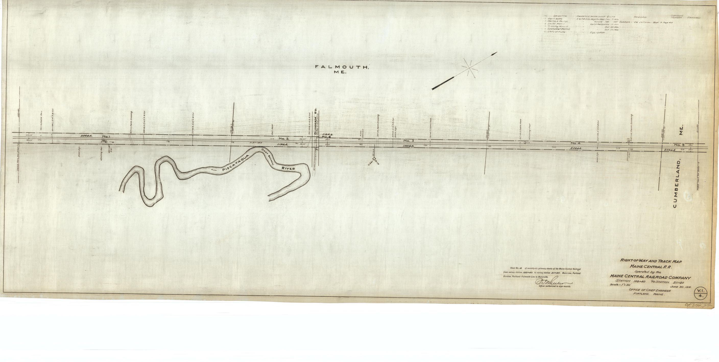
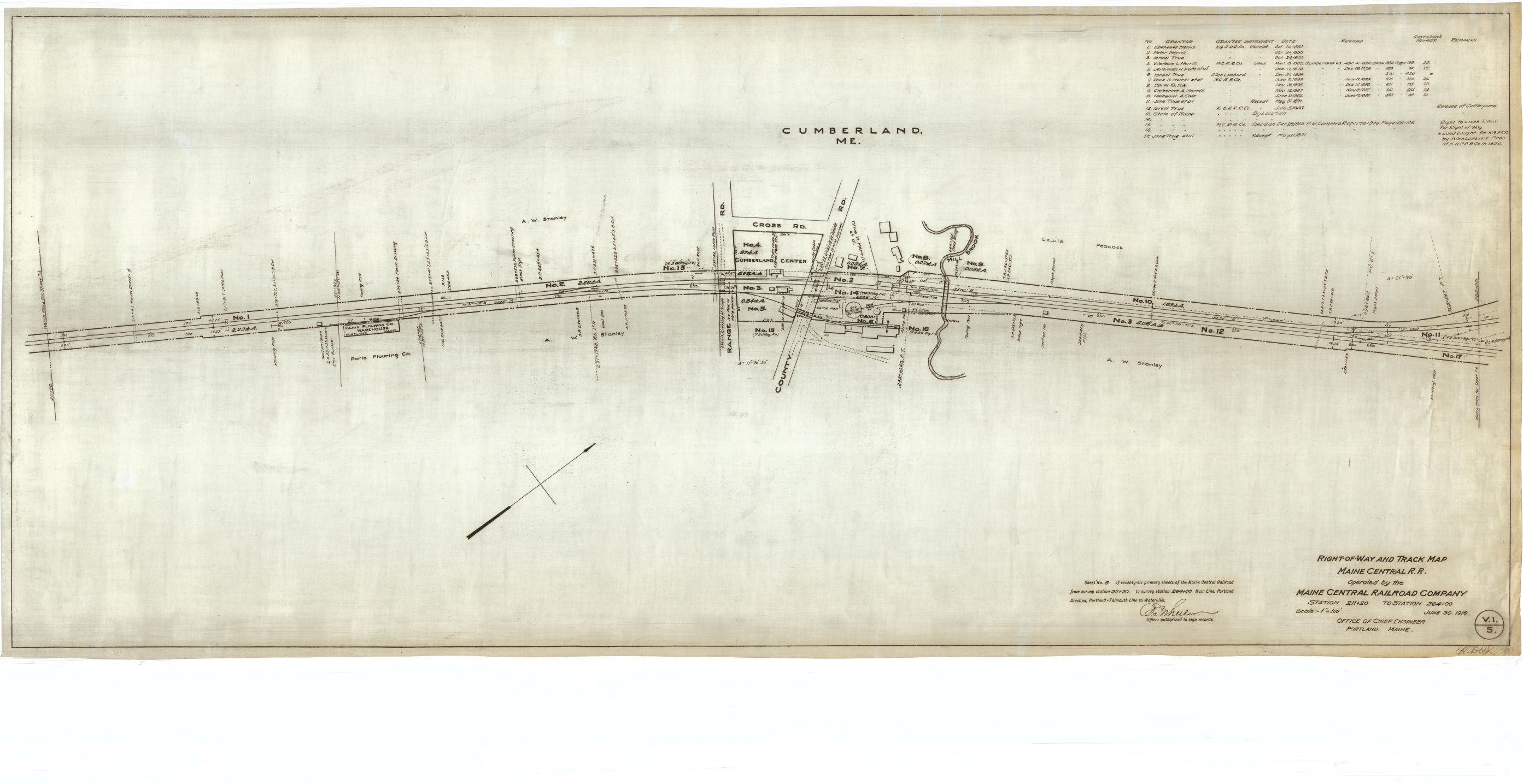
Maine Central RR. The Society’s collection of Maine Central right of way and track maps on linen was donated in February 1989 by Matt Rines and scanned by volunteer Peter Violette. The maps are dated June 30, 1916; operating divisions cited are as they were at that time.
Valuation Section 1. Portland Division Main Line. Portland/Falmouth town line to Augusta. Formerly Kennebec & Portland RR
V1-1 Portland and Falmouth V1-2 Falmouth (West Falmouth depot) V1-3 Falmouth V1-4 Falmouth and Cumberland V1-5 Cumberland (Cumberland Ctr. depot) V1-6 Cumberland V1-7 Cumberland and Yarmouth (Yarmouth Jct.) V1-8 Yarmouth V1-9 Yarmouth (Yarmouth Jct. GTR) V1-10 Yarmouth V1-11 Yarmouth and Freeport V1-12 Freeport V1-13 Freeport V1-14 Freeport V1-15 Freeport depot V1-16 Freeport V1-17 Freeport V1-18 Freeport and Brunswick V1-19 Brunswick V1-20 Brunswick V1-21 Brunswick V1-22 Brunswick V1-23 Brunswick depot V1-24 Brunswick and Topsham V1-25 Topsham V1-26 Topsham V1-27 Topsham (Cathance depot) V1-28 Topsham V1-29 Topsham and Bowdoinham V1-30 Bowdoinham V1-31 Bowdoinham depot V1-32 Bowdoinham V1-33 Bowdoinham V1-34 Bowdoinham (Harward’s) V1-35 Bowdoinham V1-36 Bowdoinham V1-37 Bowdoinham V1-38Bowdoinham and Richmond V1-39 Richmond depot V1-40 Richmond V1-41 Richmond (Iceboro depot) V1-42 Richmond (Dresden depot) V1-43 Richmond V1-44 Richmond and Gardiner V1-45 Gardiner V1-46 Gardiner (South Gardiner depot) V1-47 Gardiner V1-48 Gardiner V1-49 Gardiner V1-50 Gardiner (Gardiner depot) and Farmingdale V1-51 Farmingdale depot V1-52 Farmingdale V1-53 Farmingdale and Hallowell V1-54 Hallowell depot V1-55 Hallowell and Augusta V1-56 Augusta depot V1-57 Augusta (incl. Kennebec bridge) V1-58 Augusta V1-59 Augusta V1-60 Augusta V1-61 Augusta V1-62 Augusta and Vassalboro V1-63 Vassalboro V1-64 Vassalboro (Riverside depot) V1-65 Vassalboro V1-66 Vassalboro V1-67 Vassalboro V1-68 Vassalboro depot V1-69 Vassalboro V1-70 Vassalboro V1-71 Vassalboro and Winslow V1-72 Winslow V1-73 Winslow V1-74 Winslow depot V1-75 Winslow and Waterville V1-76 Winslow and Waterville depot
Valuation Section 2. Portland Division Main Line. Royal Jct. to Waterville. Maine Central built the section from Royal Jct. to Danville Jct. The section from Danville Jct. to Waterville was formerly the Androscoggin and Kennebec Railroad
Map 1 North Yarmouth (Royal Jct.) and Yarmouth Map 2 North Yarmouth (and a corner of Yarmouth) Map 3 North Yarmouth Map 4 North Yarmouth (Walnut Hill depot) Map 5 North Yarmouth Map 6 North Yarmouth Map 7 North Yarmouth and Gray Map 8 Gray depot Map 9 Gray Map 10 New Gloucester Map 11 New Gloucester Map 12 New Gloucester Map 13 New Gloucester depot Map 14 New Gloucester Map 15 New Gloucester (Rowe’s depot) Map 16 New Gloucester and Auburn Map 17 Auburn Map 18 Auburn (Danville Junction) Map 19 Auburn Map 20 Auburn (Rumford Jct.) Map 21 Auburn Map 22 Auburn Map 23 Auburn depot Map 24 Auburn depot and Lewiston (upper) depot Map 25 Lewiston Map 26 Lewiston (Fair Grounds station) Map 27 Lewiston Map 28 Lewiston Map 29 Lewiston and Greene Map 30 Greene Map 31 Greene Map 32 Greene depot Map 33 Greene Map 34 Greene Map 35 Greene, Wales (Leeds Jct), Leeds, and Monmouth Map 36 Monmouth Map 37 Monmouth Map 38 Monmouth depot Map 39 Monmouth Map 40 Monmouth Map 41 Monmouth (Annabessacook depot) and Winthrop Map 42 Winthrop Map 43 Winthrop Map 44 Winthrop depot Map 45 Winthrop Map 46 Winthrop Map 47 Winthrop (Lake Maranacook) Map 48 Readfield Map 49 Readfield Map 50 Readfield depot Map 51 Readfield Map 52 Readfield Map 53 Readfield and Mount Vernon Map 54 Mount Vernon and Belgrade Map 55 Belgrade Map 56 Belgrade Map 57 Belgrade depot Map 58 Belgrade Map 59 Belgrade Map 60 Belgrade Map 61 Belgrade Map 62 Belgrade (Lakeside and North Belgrade depots) Map 63 Belgrade and Oakland Map 64 Oakland Map 65 Oakland Map 66 Oakland depot Map 67 Oakland Map 68 Oakland Map 69 Oakland Map 70 Oakland and Waterville Map 71 Waterville Map 72 Waterville depot
Valuation Section 3. Portland Division Main Line. Waterville to Bangor. Formerly Penobscot and Kennebec Railroad
Map 1L Waterville (Land) Map 1T Waterville (Track) Map 2 Waterville, Winslow, and Benton Map 3 Benton (West Benton depot) Map 4 Benton Map 5 Benton Map 6 Benton Map 7 Benton and Clinton Map 8 Clinton Map 9 Clinton (Clinton depot) Map 10 Clinton Map 11 Clinton Map 12 Clinton and Burnham Map 13 Burnham Map 14 Burnham (Burnham Jct. depot) Map 15 Burnham and Pittsfield Map 16 Pittsfield Map 17 Pittsfield Map 18 Pittsfield (Half Way Siding) Map 19 Pittsfield Map 20 Pittsfield Map 21 Pittsfield depot Map 22 Pittsfield and Detroit Map 23 Detroit Map 24 Detroit Map 25 Detroit depot Map 26 Detroit and Palmyra Map 27 Palmyra and Newport Map 28 Newport Jct. depot Map 29 Newport Map 30 Newport Map 31 Newport (East Newport depot) Map 32 Newport Map 33 Newport Map 34 Newport, Stetson, and Etna Map 35 Stetson and Etna Map 36 Etna Map 37 Etna (Etna depot) and Carmel Map 38 Carmel (Damascus depot) Map 39 Carmel Map 40 Carmel (Carmel depot) Map 41 (Carmel depot) Map 42 Carmel Map 43 Carmel Map 44 Carmel and Hermon Map 45 Hermon (Hermon depot) Map 46 Hermon Map 47 Hermon Map 48 Hermon Map 49 Hermon (Hermon Centre depot) Map 50 Hermon (Northern Maine Jct.) Map 51 Hermon and Bangor Map 52 Bangor Map 53 Bangor and Hampden Map 54 Hampden and Bangor Map 55 Bangor (Engine House)
Valuation Section 4. Brewer Jct. to Calais. Formerly Maine Shore Line Railroad (Brewer Jct. to Washington Jct.), Washington County Railroad (Washington Jct. to St. Croix Jct.), Calais and Baring Railroad (St. Croix Jct. to Milltown), and Calais Railroad (Milltown to Calais)
Map 1 Brewer (Brewer depot) Map 2 Brewer Map 3 Brewer Map 4 Brewer Map 5 Brewer and Holden Map 6 Holden (Fisher’s siding) Map 7 Holden Map 8 Holden Map 9 Holden Map 10 Holden (Holden depot) and Dedham Map 11 Dedham (Egery's Mill depot) Map 12 Dedham (McKenzie's Siding) Map 13 Dedham (Phillips Lake depot) Map 14 Dedham (Allen Brook siding) Map 15 Dedham Map 16 Dedham (Green Lake depot) Map 17 Dedham (Green Lake depot) Map 18 Dedham and Ellsworth Map 19 Ellsworth (Rocky Pond siding) Map 20 Ellsworth Map 21 Ellsworth (Nicolin depot) Map 22 Ellsworth Map 23 Ellsworth Map 24 Ellsworth Map 25 Ellsworth Map 26 Ellsworth Map 27 Ellsworth Falls depot Map 28 Ellsworth depot Map 29 Ellsworth Map 30 Ellsworth and Hancock Map 31 Hancock (Washington Jct. depot) Map 32 Hancock Map 33 Hancock Map 34 Hancock Map 35 Hancock Map 36 Hancock and Franklin Map 37 Franklin Map 38 Franklin Mill Pond Map 39 Franklin (Eastbrook depot) Map 40 Franklin depot Map 41 Franklin Map 42 Franklin Map 43 Franklin
Portland Terminal Company. Images of PTC valplans were donated by Eric DiVirgilio. Although dated 1916, they may have been updated.
Valuation Section 1-A
Map 1 Saint John Street Area Map 2 Woodfords Map 3 Deering Junction Map 4 Portland (Lower Road) Map 5 Portland and Falmouth
Valuation Section 1-B. (Former WN&P)
Map 1 Portland (Deering Junction depot) Map 2 Portland (Vicinity of Riverside St.) Map 3 Portland and Westbrook (S.D. Warren) Map 4 Westbrook (Cumberland Mills depot) Map 5 Westbrook